For more than a decade, survey flights have crisscrossed the United States using gravity instruments to calculate a new sea level in an effort that will save the country billions of dollars on infrastructure projects.
And while that’s important for things like floodplain mapping, in Colorado, something else was at stake: Would Sunshine Peak in the San Juan Range still be a 14er?
A report released Thursday from the National Geodetic Survey had the potential to reshuffle the heights of Colorado’s mountains, maybe even moving Sunshine Peak from Colorado’s shortest 14er to its tallest 13er.
And while it did reshuffle some mountains, in the end, it did not take away one of the state’s 53 iconic 14,000-foot peaks.
(Depending on the source, the number of 14ers in Colorado varies. This has to do with definitions on what does and does not separate one prominence from another, which has to do with vertical drop/rise from the saddle separating two peaks. A conversation for a different day — although one that can be more easily answered with this new data.)
'Demoting' mountains
The physicist working on the project out of Boulder said he knew the stakes for the Colorado data might be higher than other areas.
“Somebody asked me, if we’d lost one, like the scientists that got rid of Pluto as a planet, would you feel guilty for demoting it?” said Derek van Westrum, a gravity scientist with the National Geodetic Survey. “But the interesting thing about Sunshine now is it's no longer the lowest. It turns out it's still above 14 but it's Huron Peak now.”
Sunshine Peak became a source of concern — well, more like a source of curiosity — when preliminary data from the study suggested that Colorado’s tallest mountains might be overestimated by a couple of feet.
“We quickly realized, ‘Oh, there's a problem with the old datum.’ There's kind of a tilt to it. So we knew that in Florida, things were about right, zero was zero," van Westrum said. "But as you move north and west, the datum that we're using for height was actually deviating from sea level significantly. And so in Colorado, we knew things were going to drop by about two feet.”
However, that two-foot drop was not consistent across the board. It highlights just how variable the previous system for measuring elevation was, and how accurate the new gravity-based modeling is.
How do we measure elevation now?
The program behind this new report was not particularly interested in peak rankings.
Started in 2007, the idea was to create a new baseline for sea level nationwide. Historically, van Westrum said, sea level was just an average, and heights were measured off of that, or off of survey markers stamped in the ground.
The new data informs something called the orthometric height — as opposed to ellipsoidal height — which is really important if you need to know which way water will flow.
“We take your GPS measurements, we then correct it, it's called the orthometric correction. You now have what's called an orthometric height. And if my orthometric height is higher than your orthometric height and we make a ditch from my house to your house, we know water will flow downhill,” van Westrum said.
The measurements even account for the density of rock beneath the surface of the ground, which may not impact Pikes Peak, but will dictate where water flows.
To get that new information, the National Geodetic Survey, which is housed within the National Oceanic and Atmospheric Administration, spent 15 years flying planes over the United States with specialty instruments that measure gravity.
Those gravity measurements, with a pinch of math, could determine the elevation of an object as though sea level were directly below it, as opposed to measuring it off of a bronze plaque epoxied to the summit of Redcloud Peak.
The new measurements could have major money implications
This specificity will have major impacts in a plethora of fields, though van Westrum points to things like floodplain mapping and commerce.
“There are all sorts of other transportation-type things — If you have a big boat at low tide, you don't want to hit the bottom of the river in say, New Orleans … knowing where water will be is critical and you can now have very precise information. Like, okay, it is safe to bring a boat in there now and you can increase commerce,” van Westrum said.
A report from NOAA estimated the financial implications of the improved measurements to be in the billions, possibly as high as $13 billion in savings.
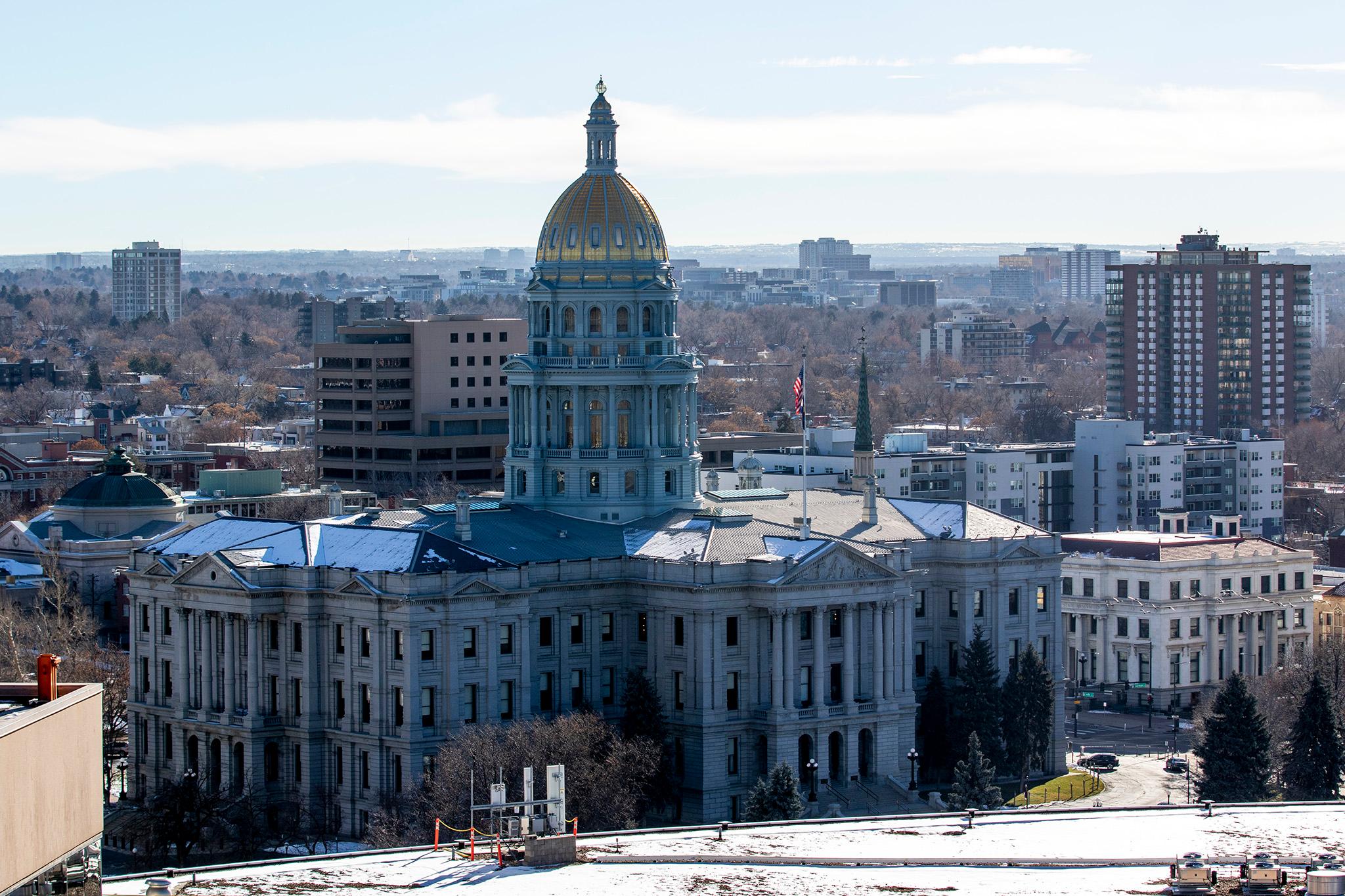
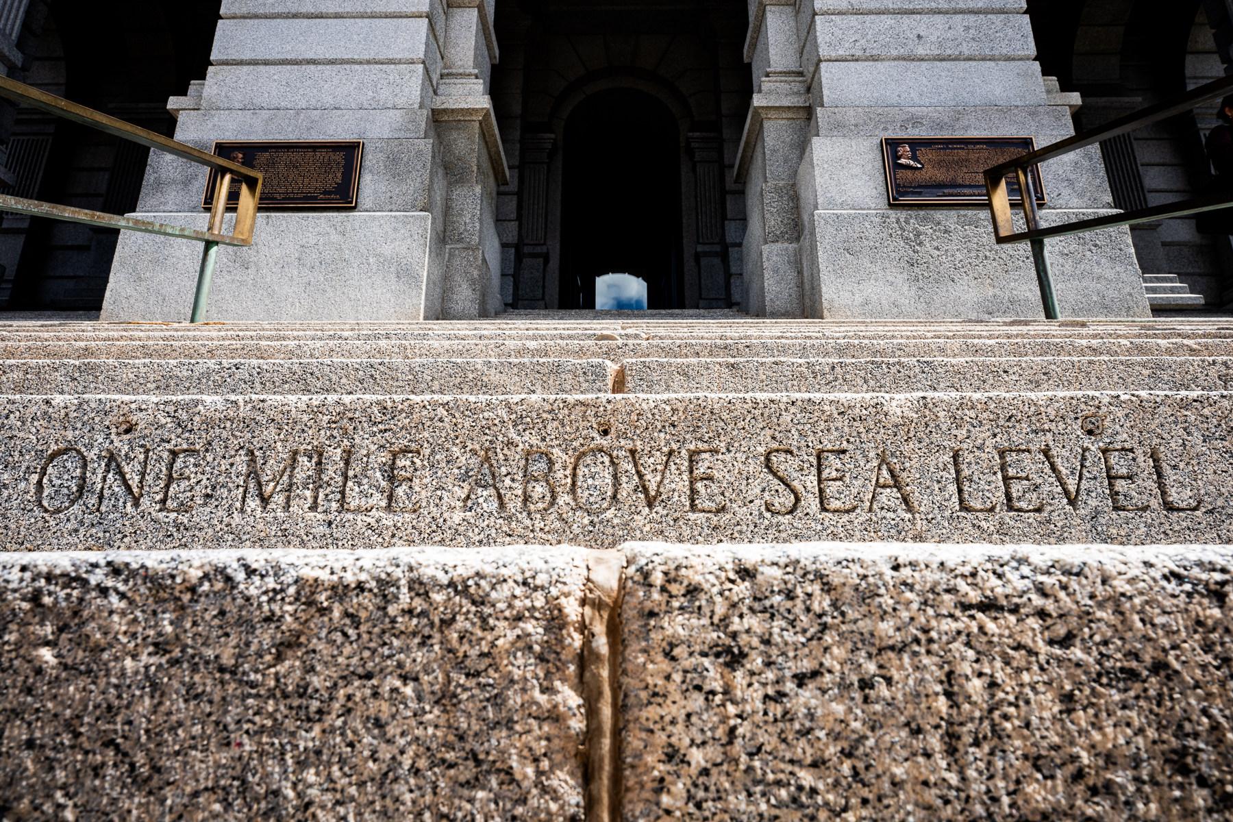
The new data also has implications for Colorado’s State Capitol building, where the city’s official mile-high status has been marked on the steps leading up to the building. Different marks have been placed over the years as information changed and van Westrum said it may need to change again.
“So, because sea level is (with the new system) two feet higher than we thought it was, that means if you want to be a mile above that, you need to move the marker step two feet up,” van Westrum said.
By sheer luck, he said, the accurate measurement is actually closer to where the first marker was placed nearly a century ago. Subsequent markers were later placed up a few steps or down a few steps as information improved.
The other advantage of the new elevation system is that it can be adjusted as sea level changes, which means that the marker may have to climb another step or two 20 years from now.